Spatial union makes it faster to go from multiple files to powerful analytics


When working with any data sources, it’s common to append, or union, two or more files to broaden analysis to use a larger set of data. For instance, you might have files of sales data separated by year or territory, or historical boundary datasets that you want to analyze to see changes over time. In each case, you want to combine the files to explore the data.
In the past, Tableau only supported unioning non-spatial files, but starting with Tableau 2020.3, we’re including support for spatial file data sources in unions! Spatial unions allow you to append multiple geographic files from the same data connection into a single data source, offering easy visualization of multiple geographic locations or times. With all of your datasets unioned together you can then turbocharge your analytics by combining your newly unioned data with the other great spatial functionality in Tableau. Let’s take a look at what’s possible with the new spatial union feature.
Explore change over time
Let’s start by looking at how spatial union can help you explore changes in your spatial data over time. In this example, we’ll look at hurricane paths from the NOAA and NWS National Hurricane Center to see how the predictions about impacted area change over time—and to think about how we can better plan for potential storm impact.
The National Hurricane Center updates the predictions for storm impact every six hours, but each prediction is a separate spatial file. To look at the change over time in Tableau, previously, you would have to combine each of the files outside of Tableau. But now, with spatial union, you can simply drag and drop to make a single file with all of the data. Whenever new data is released, you can easily add it in!
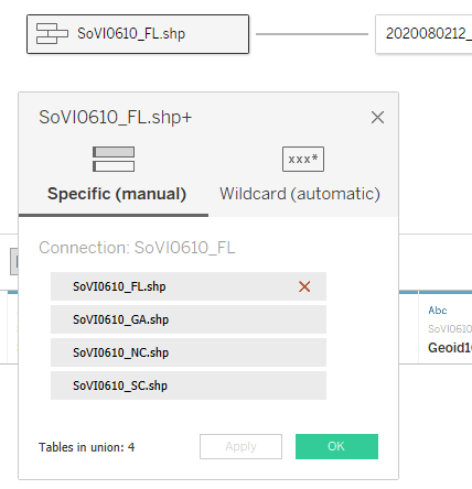
Let’s see how that works with data from Hurricane Isaias. All I have to do is connect to the folder with my spatial files and create a new union to combine each of the time steps of the data. I can either drag files over and union them manually, or I can combine multiple files at once with the New Union button.
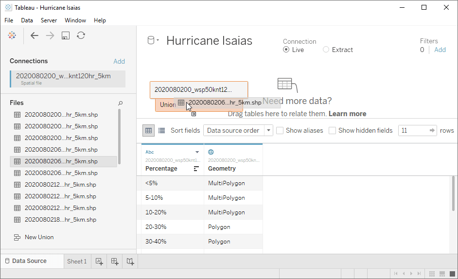
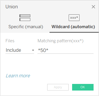
When you’re working with a large number of files, the New Union button will let you select your target files quickly with Wildcard search. For my data, I can easily grab all of the files that show the 50 knot wind speed predictions by using *50* to search the files names and add the correct files into the union:
And now I can map it all to see the time series!
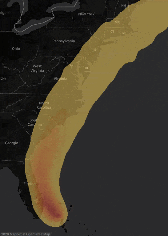
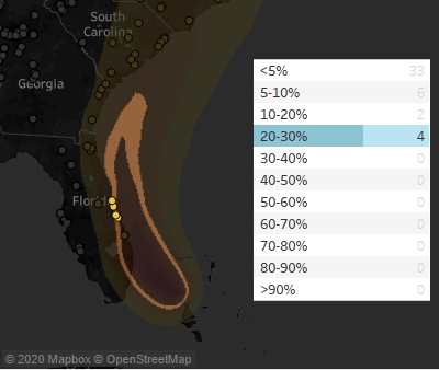
I can also do some more advanced analytics using other built in spatial functionality in Tableau. For instance, let’s think about the Waffle House Index. This is an informal metric used by FEMA to help assess impact from storms—essentially it examines the level of operation for Waffle House restaurants in the storm path. With the spatial intersection functionality in Tableau, we can then use the unioned time series to identify which Waffle Houses overlap the path at any given point in time and check the probability of storm impact to those locations.
Combine multiple geographic locations
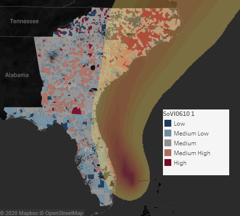
Spatial union isn’t just useful for time series. Often spatial data is broken up into multiple files for different geographies. Let’s look at how we can use spatial union to explore the social vulnerability index (SoVI) for the regions potentially impacted by Hurricane Isaias.
The storm path crosses several states, but the SoVI data distributed by NOAA is only available to download by a single state at a time. To see the entire area, we need datasets for multiple states along the East Coast. With spatial union, we can now quickly combine these in Tableau.
Once they are all combined, we can work with them as a single data source in Tableau to explore the impacts of Hurricane Isaias.
Get started with spatial file union today
Spatial union in Tableau allows you to quickly go from multiple spatial data sources to a single data source ready to map in Tableau—you no longer need to use an external tool for combining your spatial data sources!
Upgrade to Tableau 2020.3 to take advantage of this new capability, and stay tuned for more great features to turbocharge your spatial analytics in Tableau!
Related Stories

Who is Einstein Copilot for Tableau for?
 April 10, 2024
Securely Access and Analyze All of Your Data with Data Connect for Tableau Cloud
Tableau Prep Conductor Supports Custom Schedules
 March 15, 2024
Subscribe to our blog
Get the latest Tableau updates in your inbox.